

New Research Tool Maps Child Hospitalization Risk at the Address Level
Research By: Carson Hartlage, MD/PhD candidate | Cole Brokamp, PhD
Post Date: July 27, 2026 | Publish Date: March 31, 2026

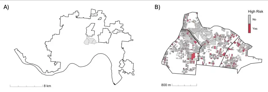
Cincinnati Children’s researchers link pediatric hospital admissions with local data on housing, parcel type, crime, evictions, neighborhood characteristics, and births to advance a more precise framework for population health
Understanding how place shapes child health is more complicated than knowing a family’s neighborhood. A child’s health may be influenced by family-level factors, neighborhood conditions, and more specific features of the home, building, or parcel where that child lives.
Traditional population health research often relies on ZIP codes, neighborhoods, or census tracts because those data are easier to obtain and compare, but larger geographies can hide variation within the same neighborhood. Two families may live a few blocks apart, or even in the same tract, while facing very different housing conditions, property values, code violations, nearby crime, and environmental exposures.
Now, a study led by Cincinnati Children’s researchers demonstrates a more granular way to study those risks. The findings, published online March 31, 2026, in the Journal of Clinical and Translational Science, describe a modeling framework that estimates pediatric hospitalization risk for every residential address in Cincinnati by linking population-wide health data with address-, parcel-, and neighborhood-level data.
“ZIP codes and census tracts are useful for describing broad patterns, but they compress a lot of variation into a single number,” says Cole Brokamp, PhD, a researcher in the Division of Biostatistics and Epidemiology. “Address-level and hyperlocal exposures fill the missing middle between what we know about a child or family and what we know about a neighborhood. That middle layer is where many housing-related interventions actually happen: homes, buildings, parcels, and blocks.”
A more precise scale for place-based health research
Disparities in child hospitalization remain substantial. In Hamilton County, Ohio, children collectively spend about 25,000 days in the hospital each year. Prior work from Cincinnati Children’s researchers suggests those days would fall by more than 30% if children from all neighborhoods were hospitalized at the same rate as those from the most affluent neighborhoods.
The new study asks a more precise question: Which residence- and neighborhood-level factors are most associated with hospitalization risk when the address itself is the unit of analysis?
Lead author Carson Hartlage, an MD/PhD candidate in the Division of Biomedical Informatics, and colleagues linked hospitalization data from July 2016 through June 2022 to Cincinnati residential addresses. The team matched 10,085 hospital admissions to 5,704 unique addresses. They then evaluated 77,077 residential addresses across the city using 30 residence- and neighborhood-level features.
The data included parcel and housing information from the Hamilton County Auditor and Cincinnati Department of Buildings & Inspections, crime data from the Cincinnati Police Department, neighborhood measures from the U.S. Census American Community Survey, eviction filing data from the Eviction Lab, and birth records from the Ohio Department of Health used to account for where children were likely to live.
“At this scale, the technical work is crucial,” Hartlage says. “We were not just putting hospitalizations on a map. We had to make the data usable by connecting addresses to parcels and other local datasets and then build models that could distinguish places where children are likely to live from places where hospitalizations are disproportionately concentrated.”
The researchers developed two machine-learning models. One estimated hospitalization risk across all addresses. A second adjusted for child residency using birth records, which helped separate addresses with more children from addresses with higher risk after accounting for where children live.
What address-level linkage revealed
The models showed that important signals existed at multiple spatial scales. Housing code violations, nearby violent crime, and market value were among the strongest features in the address-level model. The birth-adjusted model emphasized a somewhat different set of features, but five variables appeared among the top 10 in both models:
- Market value
- Housing code violations
- Nearby violent crime
- Year built
- Fraction of neighborhood housing built before 1970.
The difference between the two models is important. A building or parcel may appear high risk because many children live there, because the conditions are associated with higher hospitalization risk, or because both are true. Birth adjustment changed which addresses were classified as high risk, suggesting that different versions of the model may be better suited for different decisions.
“What stood out was not one single factor,” Hartlage says. “It was the combination of residence-level and neighborhood-level information, and the fact that the pattern changed when we adjusted for where children were likely to live. That tells us the way we define the outcome matters. High hospitalization risk and high child residency are related, but they are not the same thing.”
The study also tested whether the address-level scores had value beyond describing past hospitalizations. When the researchers evaluated the model against hospital admissions in the year after the training period, the scores showed fair forecasting performance and performed better than simply using each address’s prior hospitalization count.
For Brokamp, that is one of the key methodological advances.
“This is not about replacing clinical judgment or reducing a child to an address,” Brokamp says. “It is about building a more complete representation of place. Family-level data, clinical data, and neighborhood-level data are all important. Address-level data add another layer that can be especially important when the intervention or how it is delivered is tied to a home, a building, or a parcel.”
Potential uses for new interventions
The study authors emphasize that address-level risk modeling is not an intervention by itself. Its value depends on whether health systems, public agencies, and community partners can use the information to act more effectively.
- Health systems could use address-level information to guide referrals to care management, medical-legal partnerships, housing advocates, environmental health screening, or anticipatory guidance for housing-related risks such as asthma triggers or lead exposure.
- City agencies could use this information to help prioritize housing inspections, code enforcement, landlord accountability efforts, or investments in areas where risk is concentrated at the property or block level.
- Community organizations focused on tenant rights, housing quality, neighborhood safety, and family support could use address-level health insights to strengthen outreach and coordinate services with health care and municipal partners.
“The point is not to make a sharper risk map and call the work done,” Brokamp says. “The point is to build a data system at the scale where action is possible, and then pair that with clinical, community, and municipal partners who can decide where interventions would be most effective.”
The same framework could be adapted to other outcomes, such as emergency department visits, preventive care completion, or total cost of care. It also could be refined for specific health concerns by adding features related to those conditions.
For example, air pollution and greenspace data could support respiratory-health applications, while information about lead service lines, older housing, rental properties, or property renovations could help target environmental health interventions.
Limits and fairness
The researchers caution that this model was built for Cincinnati and should not be copied directly to other cities. Other places may have different housing markets, different public datasets, different enforcement patterns, and different relationships between housing conditions and child health. It’s an adaptable framework, but it must be retrained and validated with local data.
The authors also note important limitations. Some data are more available in Cincinnati than in surrounding municipalities. Public and administrative datasets may be incomplete or biased. Parcel-level records often do not capture conditions within individual apartment units. Birth records are an imperfect proxy for where children live over time. Children in foster care were likely underrepresented because of address-filtering decisions in the study.
Fairness is also a central concern. The study found some differences in model performance by census block-level racial composition, and the paper notes that housing code violations, crime reports, and other public datasets can reflect reporting behavior and enforcement history as much as underlying need.
“Address-level data can improve precision, but precision is not the same thing as fairness,” Brokamp says. “Housing code violations, crime data, property values, and eviction records reflect who reports problems, how agencies document and respond to complaints, and the history of investment and enforcement in a city. These models should be interpreted with community partners and used to support communities, not to label them.”
Next steps
Future work will focus on geographic expansion, more time-varying data, partner engagement, and patient-level validation. The researchers also note the need for more open and harmonized local datasets if similar work is to be adapted across municipalities.
For now, the study offers a proof-of-concept for a more precise approach to place-based child health research. Larger-area summaries remain useful for describing broad disparities, but they are often too coarse to guide residence-or parcel-level action.
Address-level modeling adds the missing middle: a way to connect health outcomes with the homes, buildings, blocks, and parcels where many interventions can actually occur.
| Original title: | Precision risk assessment for pediatric hospitalization using address-level data in Cincinnati, Ohio |
| Published in: | Journal of Clinical and Translational Science |
| Publish date: | March 31, 2026 |
Research By


As a biostatistician, epidemiologist and geospatial data scientist, I specialize in informatics and machine learning, with applications to population-level environmental, community and health outcome data.

Latest Posts

About this blog
The Research Horizons blog features news and insights about the latest discoveries and innovations developed by the scientists of Cincinnati Children's. This blog does not provide medical advice, diagnosis, or treatment. Email researchnews@cchmc.org with questions or ideas.
Subscribe to Our Newsletter